What is 3D Scanning?
3D Laser Scanning is a non-contact, non-destructive technology that digitally captures the shape of physical objects using a line of laser light. 3D laser scanners create “point clouds” of data from the surface of an object. In other words, 3D laser scanning is a way to capture a physical object’s exact size and shape into the computer world as a digital 3-dimensional representation.
3D laser scanners measure fine details and capture free-form shapes to quickly generate highly accurate point clouds. 3D laser scanning is ideally suited to the measurement and inspection of contoured surfaces and complex geometries which require massive amounts of data for their accurate description and where doing this is impractical with the use of traditional measurement methods or a touch probe.
The use of laser scanning and point cloud data helps lower the time, effort, and cost of process plant retrofit engineering and construction projects. It extends the use of 3D CAD to more projects. Point cloud integration also helps in the planning of existing plant re modelling by coupling existing plant configuration provided by point cloud scans with 3D model displays.
The benifits are accurate “as builts”, Easily & simply add additional plant & equipment to existing facilities, Negates need for costly manual surveys, Visualisation of new equipment into existing features.
Typically used for:
- Documenting as-built conditions
- Design Development
- Clash detection
- Asset and facilities management
- Visualisation
Envision has invested in the latest in 3D laser scanner’s.
Using a Leica BLK360 or RTC360 captures the world around you in a high-accuracy point cloud.
- BLK360: range: up to 60 m, accuracy: 4 mm @ 10 m/ 7 mm @20 m, point rate: 36,000 pts/sec, scan duration: 3 min.
- RTC360: range: up to 130 m, accuracy: 1.9 mm @ 10 m/ 5.3 mm @40 m, point rate: 2,000,000 pts/sec, scan duration: 1 min.
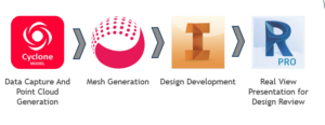
Envision use Cyclone to process the date and generate a mesh model. Inventor to model the new equipment and ReCap Pro for real View presentation of models in the point cloud data.